
|
Sunday May 1st 2022, this was a pleasant surprise. I had woke up late this morning as nothing of interest was expected to happen in the skies, there was no rush to do anything except chill out. Roisin and I had planned to drive to Co. Armagh for the day, there had been heavy overnight rain from a slow moving front after a week or more of glorious high pressure weather and today was forecast by the Met Office to be dry but completely grey and cloudy so it seemed nothing of interest could happen in such conditions. Before I got out of bed I checked my lap top and noticed BBC Newsline had forecast sunny spells and scattered showers in the afternoon, that was interesting because after a front showers like that would indicate convection, however after consulting the GFS CAPE charts there was barely a thing of interest and the lifted index was positive.
Roisin and I ate a late breakfast then I opened the back door which faces east, beyond the neighbour's rooftop we have a fairly decent view in that direction, beyond is nice photogenic countryside with fields and a hill then beyond that somewhere out of sight is the shore of Lough Neagh. When I looked over those fields with sleepy eyes my brain immediately smarted, there was a line of very dark storm clouds brewing over the countryside, in fact, one section had a very black base low to the fields which really got my attention. I said to Roisin those bases look interesting then upon closer inspection I was sure I could see rotation, I said to Roisin ''those clouds are rotating, keep an eye on them, there could be funnels''. I went outside, opened the van door, grabbed the 100-400mm lens, I noted their wasn't a breath of wind and the air felt muggy and warm, there were good breaks in the clouds with blue skies and towers with bases in the distance, I began to have a good feeling and trusted my instincts.
I attached the lens to the DSLR and ran upstairs to get a higher view point then opened the skylight on the roof and watched that menacing looking black base with camera in hand. That base was rotating very well, I yelled down to Roisin that the rotation had gotten stronger and she said she was watching it too from the backdoor. I watched the base rotate for at least 15 min's with scud swirling like a merry-go-round and at the same time lifting upward, it was impressive to watch and I felt certain a funnel cloud could drop at any moment. I had the camera to my eye watching through the viewfinder with settings selected just waiting for that magical moment to happen, witnessing the birth of a funnel cloud, but the base kept rotating with no lowering. After a period of observation I noticed precip breaking out in proximity to the base, I considered this to be a sign that the show was over, normally when precip breaks out under towering cumulus the cold outflow air tends to undercut the warm inflow destroying any chances of a spin up so I decided to get on with things.
Before we left the house I checked the models, a very slack flow today so the wind was dead calm, always a good sign, this also meant that local convergence zones can form inland increasing the chances of towers and perhaps rotation. The maps also showed warm air aloft so the mid levels would be capped so no storms, however they did show 100 SBCAPE, such conditions can be good hunting grounds for funnel clouds so I decided I would stay on full alert the rest of the day. I did a quick post on facebook and twitter reporting a rotating cloud base for 15 min's and letting everyone know to be on alert for funnel clouds across N. Ireland.
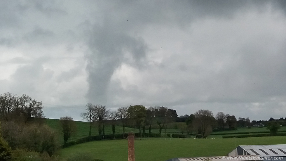
Roisin and I hit the road, we stopped briefly in town to get a coffee and blue berry smoothie from a cafe in town, there was a moderate strength shower falling at the time. We then began driving through the town to the south side and emerged from the precip, just as we where approaching the roundabout near the Dungannon road I looked to my 10 o'clock position and got a major shock. There in full view was a fully formed funnel cloud!!!!, I think I said to Roisin ''Holy sh*t massive funnel cloud to the left'', Roisin was driving and I was in the passenger seat, she casually turned her head to the left and instantly froze, she was in disbelief, in truth I was stunned also, both of us rooted to our seats finding it difficult to believe what we were seeing. Dominating the sky was a large dark grey vertical cylinder spinning over the fields at close range, it was so low it was almost torching the surface, we actually thought it was too good to be true, was this for real?, however there was no question about what we were seeing. The rotation, the size, the well defined smooth edges, this was a massive rotating vortex at close range near the town, Roisin said it was like something from the USA.
Now this is the ironic part, I had anticipated funnel potential so I had my DSLR and 100-400mm lens cradled in my arms ready to deploy at a moment's notice to catch any funnels as we drove to Armagh, I find the telephoto lens is the best tool for catching funnels as they often tend to be seen under distant bases however now the long lens was rendered useless, I was holding a paper weight, the funnel was so massive it would have been a waste of time even trying to shoot with it, furthermore my other lenses where in the camera bag in the boot and there would be no time to change lenses anyway.
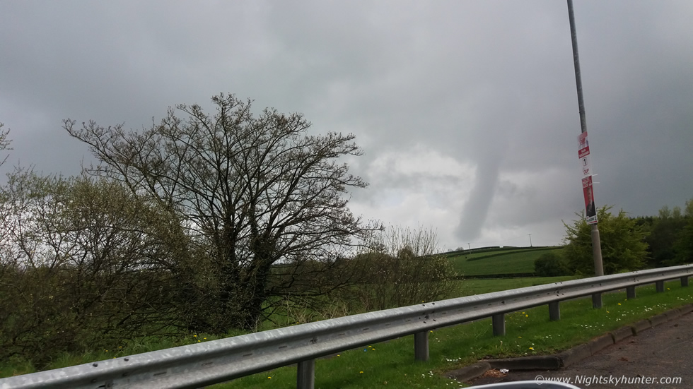 |
We where about to loose it from view so I grabbed my mobile phone and held it out the open window of the moving car and snapped several images and with amazing good fortune I managed to catch it before we lost it from sight. Please keep in mind that his is a wide angle field of view on the phone camera so in reality the funnel was much larger and closer than it appears here, even so you can appreciate how striking it was.
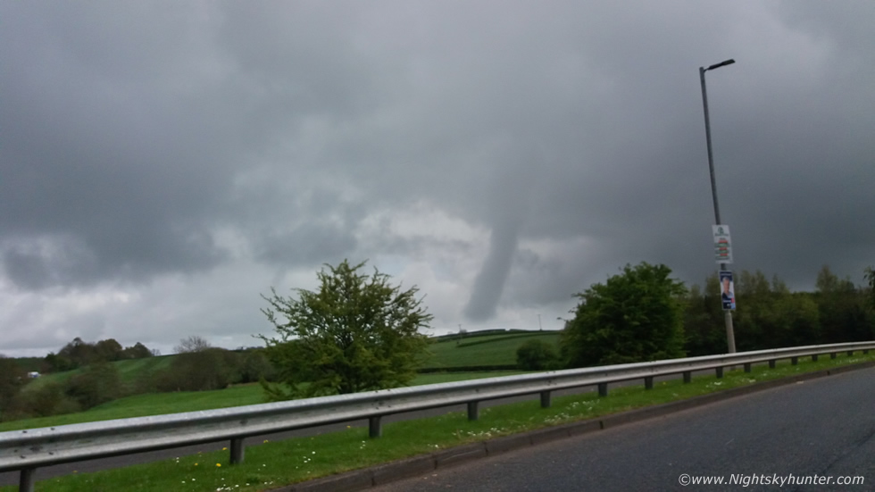 |
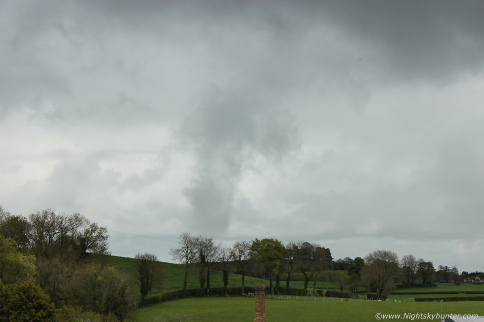
We where literally at the roundabout here and couldn't stop so every second counted, another phone snap, this time the camera missed focus, however look how far the funnel goes up into the cloud base. From our perspective the funnel was to the SE of Cookstown, perhaps in the Killymoon area and certainly not far north of Tullyhogue Fort.
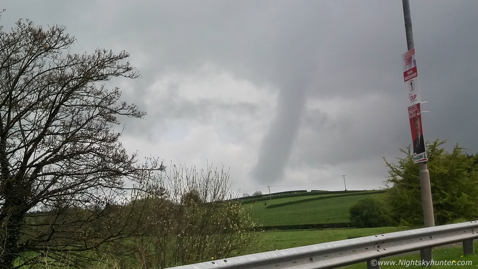 |
This is a crop from the first wide angle image with a little contrast added, look how close that is to the ground, the fields don't slope that far down on the other side of that hill, normally in the States if a funnel is half way to the ground or longer it's often considered to be a tornado, this would later be confirmed of course, however I'm speaking entirely from a visual perspective here, so based on its appearance alone there's a very high probability that this was a tornado. Likely a weak tornado however there would certainly be surface winds circulating below it, because of the countryside with no structures affected and also because of the wet fields there would be no visible signs of debris lofted in the air to provide the final confirmation.
Roisin took the option at the roundabout for Dungannon, I asked her to put her foot down and we gave chase, Roisin floored the accelerator however we had now lost the funnel behind tall trees which lined the road, we got another brief glance of it behind the service station on that road then the trees blocked it again. I asked Roisin to take the next option on the left which took us onto narrow back roads into the countryside then we came into a clearing and pulled over onto the side of the road.
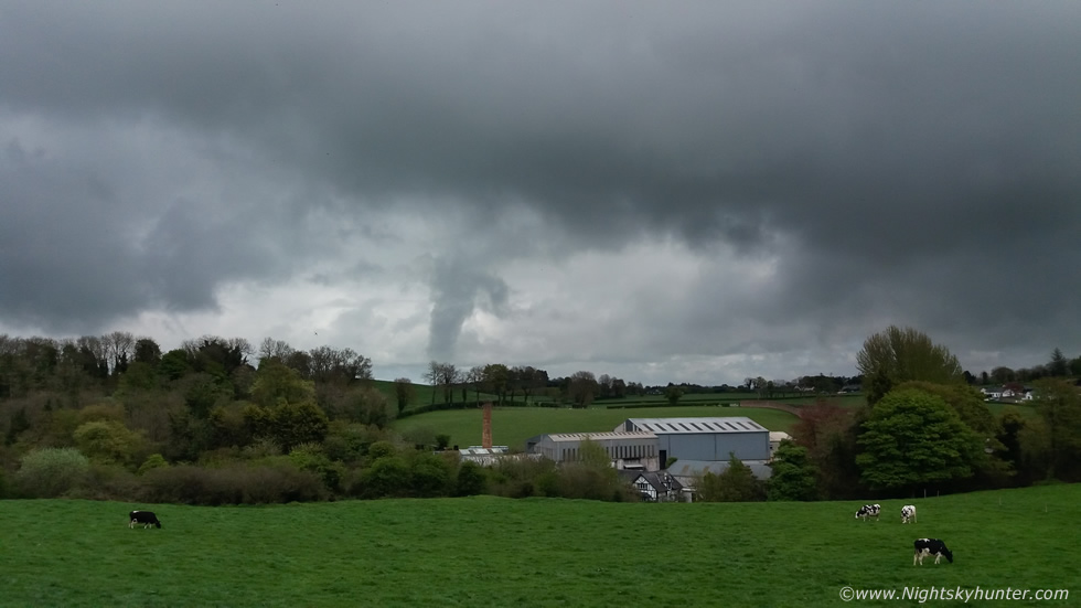 |
The funnel was dissipating and the upper portion had vanished and was seemingly no longer attached to the cloud base. However the bottom portion was still spinning away, keep in mind a tornado is the wind and not the visible funnel so even if a condensation funnel has missing segments or gone doesn't mean the wind still isn't affecting the ground.
 |
Crop from another phone snap
 |
The only DSLR image I got using the 18-55mm lens, then as we watched the bottom section relaxed and the funnel vanished into thin air and the show was over. Roisin and I were absolutely buzzing, that natural high which only comes from a good funnel cloud, we were still in shock by what we had witnessed, we had just expected a Sunday drive to Armagh but we didn't expect to see a possible tornado near Cookstown moments after we left. There's no question that witnessing a good funnel or tornado event in Ireland/UK does have some kind of effect on the observer, it's difficult to explain but feels like you have been choose by nature to witness something very special.
The only video clip I got with the phone showing the funnel for a fleeting moment. We spent the day in Armagh on high alert watching every cloud base, the sky was really talking, it was actually very warm with good solar heating and humid with low bases everywhere and good towers bubbling however we never saw any more rotation or funnel clouds. I later found out that high resolution models had shown strong vorticity in the lower atmosphere and 30 knots of deep layer shear, this combined with slack winds at the surface, likely convergence effects and low end instability had resulted in a possible tornado. This left us buzzing for the rest of the day, the season had certainly got off to a good start, despite no thunderstorms or high CAPE yet I was still fortunate enough to catch two funnel clouds close to the surface within a month. I hope this is a good omen for what might happen this Summer, I will be on the hunt for more so stay tuned.
Martin McKenna
